


In March 2022 the WFA launched TrenchMapper, its interactive web app, that allows users to explore a host of First World War maps and photographs set into the modern-day mapscape. The maps/photographs are superimposed onto a satellite view of the area (or optionally onto a road map) and you can also view any point within them in ‘Street View’ to see the area as it now exists. TrenchMapper is available for anyone accessing the WFA website, but WFA members who login to the members’ area* have the added advantage of being able to zoom in to the maps to a more detailed level and can also download two maps free of charge each month (a small charge is made for downloads outside of the free allowance and to non-members). Some background articles on the development of TrenchMapper can be viewed at our TrenchMapper help pages
TrenchMapper launched with a modest collection of some five hundred maps and a handful of photographs but thanks to a concerted effort by over forty WFA volunteers, eighteen months on we now have over 6,500 maps and photographs online covering the Home front, Gallipoli and the Western front, where we have French and German maps as well as British. Each of the Western Front maps has been scrutinised by our volunteers to identify the points of interest that abound and these have been added to the database, so are now all searchable within TrenchMapper. Over 46,000 such points have been recorded ranging from trenches, the predominant feature, to woods, farms and war graves (see below for a full list). So if you want to see the map(s) that contain details of the trench where ‘great uncle Sidney’ fell for example, enter the trench name in the TrenchMapper search field and a list of the appropriate maps will appear for you to explore.
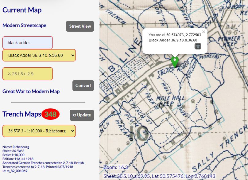
Above: Use TrenchMapper to insert the name of the trench you are looking for; in this case we have located 'Black Adder Trench' simply by typing 'Black Adder' into the search box.
Impressive as this is, TrenchMapper continues to be developed apace. Further map collections will be added and more Western Front German maps, Italian front and Salonika maps are in the pipeline. Again, points of interest will be recorded in the database as each map is processed to give one of the most comprehensive research tools for First World War maps available anywhere, it now being the largest single online depository of maps with the widest geographical ‘reach’. Our Gallipoli collection, for example is unequalled and with the other fronts already online or available soon it is a vital tool for anyone with an interest in the Great War.
And further technical enhancements are planned for TrenchMapper too. Work is underway to optimise the system for use on mobile phones and tablets so that you can use TrenchMapper literally ‘in the field’. An elevation profile of the map will also be available and further down the line there will be a feature to present the map in 3D.
TrenchMapper is only made possible by the combined efforts of dozens of volunteers who have given their time freely over many man/woman hours of work and we are extremely grateful to all who have contributed. If you have not yet tried TrenchMapper then just click on the link on the home page of the WFA website. You will find detailed Help pages to guide you through and within a short time you will be exploring the cartography of over a century ago.
Breakdown of TrenchMapper Points of Interest, September 2023
|
Type |
Count |
Percent |
|
Trench, sap, dugout, redoubt |
19,317 |
41% |
|
Farm |
6,318 |
14% |
|
Building, camp, hut |
4,342 |
9% |
|
City, town, locality |
3,311 |
7% |
|
Wood, forest |
3,298 |
7% |
|
CWGC cemetery, monument |
2,289 |
5% |
|
Church, crucifix, chapel |
1,957 |
4% |
|
Road, lane, street |
1,879 |
4% |
|
River, stream, dam, bridge |
1,647 |
4% |
|
Railway line, station, junction |
1,195 |
3% |
|
Hill, valley, spot height |
828 |
2% |
|
Other |
381 |
1% |
*Members who login to the members’ area enjoy access to other facilities as well as TrenchMapper including Pension Records and past publications, eg. Stand To, Firestep, Purnell History of the First World War etc