One map out of 10,000, and how it tells a story
With over 10,000 maps now available on TrenchMapper, we just want to pick one particular map out and show how it tells a story.
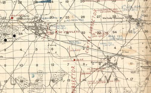
Using TrenchMapper, it is possible to find the map shown below (note this image is a 'snip' and is just a small part of the larger map)
Bill Frost, one of the driving forces behind project, says this:
The map is undated, but my eye was caught by the Somme – Ancre junction, the position of the 1st Cavalry Division forward of Corbie and the annotation showing Corps Schools and small groups of Americans well forward. Even a Survey Company marked as 350 rifles. When I looked closely I could see "March 29th" in faint crayon and the American presence suggests the year 1918.
When my grandfather’s division boarded over 200 London buses to get to the Somme they occupied Heilly Chateau and surrounds. My grandfather’s account specifically mentions helping themselves to champagne from the cellar and sheep. The unit war diary just says rations were supplemented from ‘other sources’.
His brigade commander, Brigadier-General Cannan, walked along the ridge of the Somme and recorded the 1st Cavalry Division in action, giving them credit for halting the German advance. He greatly admired what they did and stayed until his party came under direct machine gun fire. Interesting to have two observations in the same sentence contradicting the Great War myths – cavalry were unsuitable for WW1 and generals were always safely ensconced in chateaus well behind the front line.
The map shows how desperate the defence was. The cavalry brigades are only screening 4km in front. Right behind them are hodgepodge units dotted around the sector, given names such as 100 Americans, Corps Schools (200 rifles), 150 men, 150 straglers [sic], Field Survey company (350 rifles), 200 R.E. and 66th Div Details. The 16th Div was down to 1,000 men at Le Hamel.
Desperate times indeed.
To locate this map on TrenchMapper simply go to the 'main menu' and click it and then click 'jump to'.

In 'jump to' click 'map id' and insert the name of this map (wo_95_1097_004)
Latest news


