Introduction to 'TrenchMapper™'
The Western Front Association is delighted to announce a major new initiative which we are certain will be of great interest to everyone who has an interest in the First World War.
We have launched a web-based portal which enables members and non-members to use our new ‘TrenchMapper™’ to interact with thousands of trench maps, images, and sketches that were created during or immediately after the Great War.
TrenchMapper™ covers mostly the British held sector of the western front, but we also have maps of Gallipoli and the UK, with maps of the Italian and Salonika fronts also recently added.
The most innovative aspect of this is that you can use this free portal to see hundreds of maps for most ‘front line’ sectors of the front. At the moment, we have around 10,000 maps and images available, but this will grow over coming months.
What TrenchMapper™ does
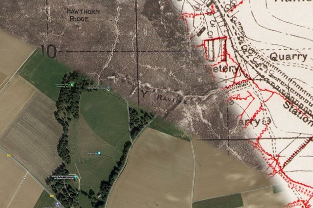
The Western Front Association’s TrenchMapper™ is a cutting-edge system that enables users to identify from a Google satellite image, street map, or topographical map the area of the front they are interested in. It is then easy to locate the maps (or mosaics of photographs) that appear at that point. The maps range from those that appeared in the Official History (and cover massive areas of the front), through to 1:40,000, 1:20,000 and 1:10,000 trench maps, and even a number of 1:5,000 maps. Mosaic images have also been built from RFC/RAF photos which show fine detail (trenches, craters, pill boxes, tanks, artillery barrages in progress). We also have German and Turkish maps available.
Using an ‘opacity’ slider it is possible to incrementally compare the maps and mosaic photos to what is on the ground ‘now’.
There are lots of other ‘bells and whistles’ such as the ability to go to Google street view, measure distances from point to point and use advanced search functions. Not all functions will be needed by all users, but we do feel that the advanced options may well prove extremely useful to some members.
Who can use this?
This is being made available to members and non-members of The Western Front Association, however, those users that are members can ‘zoom’ into the maps to a much greater degree of detail than non-members