


Many maps of the Great War were produced using Lithography, either by the Ordnance Survey or locally but a significant number were hand drawn. Whilst the cartographic skills of the draughtsman varied, one outstanding example was drawn by Lt. Col. S. Mildred, the CRE of 4th Division. As was common then, the base map is drawn and printed first then detail added later. This map, tagged ma_001100 on TrenchMapper, was printed by 4th Division Topographical Section and published on 8 October 1915.

Above: Part of map ma_001100
Col. Mildred added a great deal of information leading up to the Battle of the Somme in July 1916 in which 4th Division was heavily involved. Whilst the exact date of drawing the map is not given, it is almost certain that it was used in the planning the battle. Lt. Col. Mildred donated the map to the Imperial War Museum in 1960.
The map, ma_001100, is on starched linen and the detail added in ink with great skill. Whilst it is possible to erase mistakes using a blade to scape the surface, this is an unforgiving way to create maps. Not only did Lt. Col. Mildred draw detail in ink, he also took the trouble to colour the roads, woods and other features in pencil. It is an interesting exercise to trace a modern map and add detail, an activity that highlights the great patience and skill required to make a map of this quality.
A fragment is shown here depicting Redan, Auchonvillers and Y Ravine, including the area destined to be the Newfoundland Memorial Park.
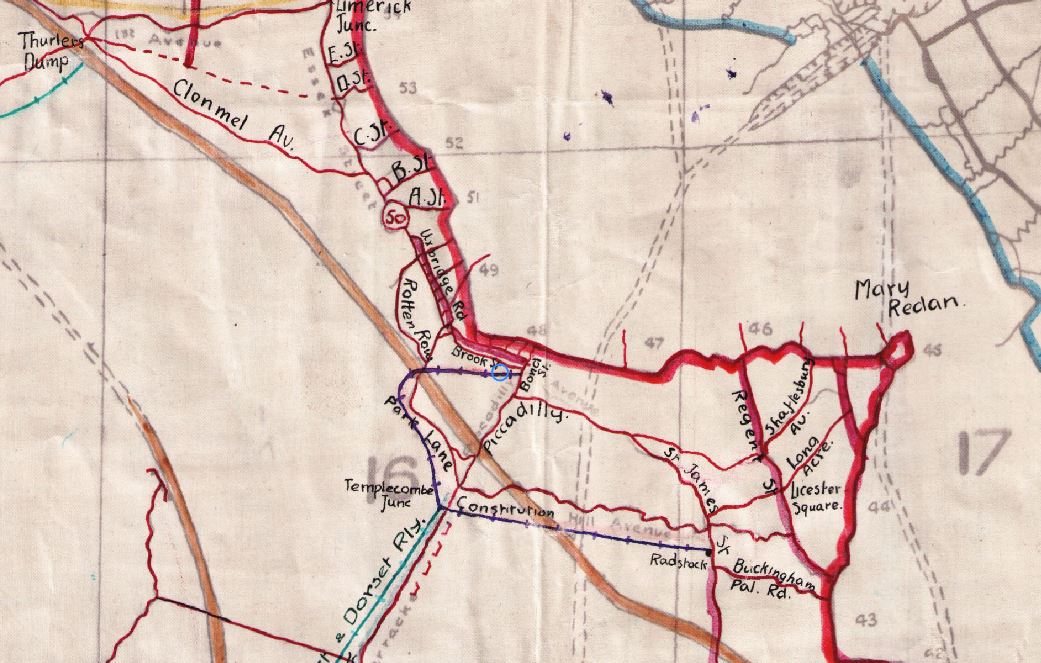
Above: Another part of m_001100
The map shows Fire and Communication trenches and Trench Tramways of two kinds, “Wood” and “Decauville”. This latter term refers to a railway system of locomotives and rolling stock built to the design and specification of a manufacturing company formed by the French railway pioneer Paul Decauville. From 1875 until after the Second World War, they produced a portable track system, originally 400mm (15 ¾ inch) gauge, but this was later refined to 500mm (19 ¾ inch), and then to 600mm (1ft 11 5/8 inch). This system was used by the French military from at least 1888 when they adopted the 600mm gauge to supply the Maginot Line and elsewhere with arms and ammunition.
There are still the remnants of the Decauville system running at various times as le Petit train de la Haute Somme. This runs to the south of the river Somme at the little village of Froissey, on the opposite river bank to Bray-sur-Somme.
To find the map in TrenchMapper, first move to Beaumont-Hamel by putting Beaumont in the search box then, from the Main Menu, choose Jump To then Specified Map ID and insert ma_001100. Zooming in it is easy to see Col. Mildred’s mastery of the pen.
A 'quick link' is here> m_001100
The Redan
A week before the official end of the battle, an artillery barrage was planned on the Redan Ridge as shown on a hand drawn map, m_82_000522 (shown below).

A note in the margin refers to the Red Line for the 51st Highland Division on 13 November 1916 and signed by CRE 51st Division. It is drawn to a scale of 1:5,000 and shows the planned timed lifts.
This map can be previewed here m_82_000522
Following the barrage, a hand drawn intelligence map shows the results of the barrage in considerable detail, this is m_84_001028.

Above: m_84_001028
Once again, the map can be previewed here: m_84_001028
This has the printed information Trenches corrected to 12/10/16 so the hand-drawn additions were on top of a freshly produced base map, one produced by the Royal Engineers.
All three of these maps show a high level of skill to draw them; whilst Lt. Col. Milred may have had the luxury of an office to draw his, the other two have the hall marks of items made in the field and not intended for publication other than inclusion in reports. It is at this point that the activity to trace or draw a map takes on a new dimension, to compare one’s efforts to those who worked in a dug-out, by candle light with all the attendant horrors of war.
Howard Anderson